Alignment Of Irrigation Canal | Detailed Explanation
Desirable locations for irrigation canals in any gravity project, their cross-sectional designs, and the cost of construction are mainly governed by geographical and geographical conditions Different ways of cultivating the land.
Main canals should transport water to the highlands of the arable region. Branch canals and dispensers deliver water to different parts Irrigated areas.
In projects where the land slopes are relatively flat and uniform, this is advantageous to connect canals on a basin of irrigated areas. The natural limits of command Such irrigation canals are drains on either side of the canal.
Connecting the canal This ensures gravity irrigation on both the basin (main, branch, and distribution) The sides of the canal. Furthermore, the drainage flows away from the basin and therefore there is no drainage You can cross a canal attached to the basin.
Thus, a canal attached to the basin saves the Cost of construction of cross-drainage structures. However, the main canal has to be removed From the river, which is the lowest point of the cross-section, and this canal must be mounted Basin at as short a distance as possible.
The slope of the ground at the head of the canal required is higher than the slope of the bed and, therefore, the canal needs some distance To mount the basin. This can be illustrated by Figure 5.2, in which the main canal is taken off from the river at P and the basin at Q.
Let P be the level of the canal at 400 m and The height of the highest point N along the MNP section is 410 m.
Imagine being ground The slope of the Q (395 m) point on the basin is 15 m from N, 1 km per slope Km If the slope of the canal required is 25 cm per km, the length of the canal is PQ 20 km.
Between P and Q, the canal crosses small streams and, therefore, cross-drainage construction
structures are necessary for this length. In fact, alignment is influenced by PQ Substantially by the need to provide suitable locations for cross-drainage structures.
The exact location of Q is determined by the experiment so that the coupling leads to of PQ economy
Plus efficient system.
Furthermore, the canal is the ground, in the basin of the PQ On the side of the valley (i.e., on the side of the river) is the height of the ground.
So, in this part of the canal, only one side of the canal (i.e., the riverside) can be irrigated.
Once the canal reaches the basin, it is usually placed in the basin, except for some scenarios such as the looping basin in R in Figure 5.2.
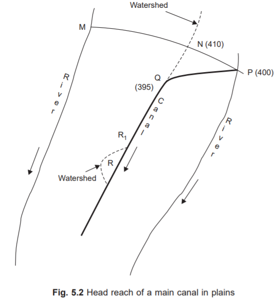
In an attempt to retain the canal Direct coupling, the canal may have to leave the basin near R the basin in the canal and the R area can be irrigated by the take-off distributor in R1 And follows the basin.
Also, in the R area, the canal can cross some small streams, and, Therefore, some cross-drainage structures may need to be constructed.
If the basin passes Through villages or towns, the canal may have to leave the basin for some distance.
Also Read: Advantages of the canal line
In the hilly areas, the conditions are very different compared to the plains. Rivers It flows into valleys below a basin or mountain and may not be economically viable Take the channel over the basin.
In such cases, there are contour channels (Fig. 5.3) Built-in Contour channels follow the contour when performing the required longitude slopes.
It continues thus and the river slopes are much steeper than the bottom of the canal required The sloping canal covers more and more area between itself and the river.
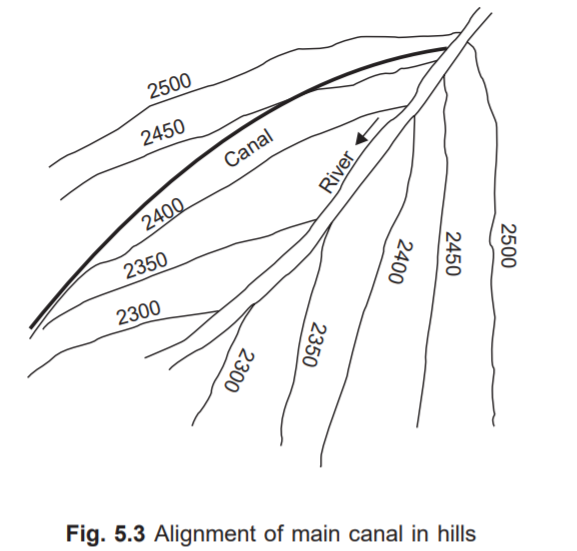
Should be He noted that the more fertile areas in the hills are only at a lower level. Practical arrangements for finalizing the channel network for the canal irrigation project channels are marked on a map prepared during a detailed survey.
Is a large-scale map The details of individual channels are required to work. It does, however, depict a small-scale map The entire order of the irrigation project is also desirable.
Also, watch this video on the alignment of the irrigation canal:
The alignments identified above that map are transferred to the field and adjusted wherever necessary. these adjustments are also transferred on the map.
The alignment on the grounds is marked by small stone pillars Every 200 meters. The middle line on these pillars coincides with the exact alignment. Between the adjacent pillars, a small trench dug into the ground, marking the alignment.
Thank you for gathering the knowledge about alignment of irrigation canal.
Also Read: Measurements of precipitation